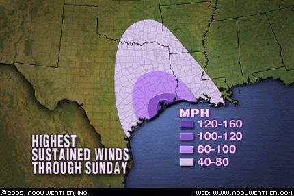
The strongest winds will occur from Friday night into Saturday morning, concentrated along and just inland from the northeastern Texas coast. In this area, winds of 120 to 150 mph with higher gusts are expected. Winds of this magnitude will cause catastrophic damage, on the order of what we saw in southern Mississippi where Katrina made landfall. Winds in downtown Houston are expected to reach 100-120 mph, especially in high-rise buildings and skyscrapers. Winds of this magnitude will cause many windows to break, with dangerous, flying debris all across the city. As the storm tracks inland, winds will blow to hurricane force for up to 150 miles inland right along the center's path, enough to cause widespread damage to trees and power lines along with some structural damage. So be prepared for a large portion of eastern Texas and western Louisiana to be without power for an extended time.
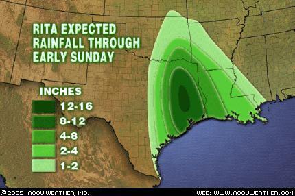
Torrential rain will also be a concern with Rita as it blasts ashore. A large portion of eastern Texas and western Louisiana should receive more than 4 inches of rain, enough to cause some flooding problems. There could be as much as 15 or 16 inches in some spots. Rainfall of this magnitude will cause significant flooding problems. So if you live in an area that is prone to flooding, be aware that you may be dealing with a potentially life-threatening situation as some point this weekend.
Story by AccuWeather.com meteorologist Gerald Mohler


No comments:
Post a Comment